Marin County’s new supervisorial district mapping process was completed on December 14 with the adoption of an ordinance by the Board of Supervisors.
The Board considered months of engagement with four public redistricting hearings, several additional workshops, map proposals from residents, demographic data from consultants, and nearly nine months of bilingual outreach.
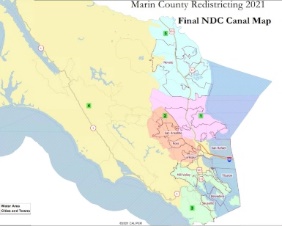
The once-a-decade responsibility to adjust the county’s supervisorial district boundaries to reflect population changes was formalized on December 14 when the Board adopted an ordinance accepting a map called Final NDC Canal Map. Board members gave it unanimous support on December 7 with the stipulation that staff return on December 14 with a few minor technical changes.
The new map, which mostly includes changes in downtown San Rafael, goes into effect immediately. By law, the Board needed to adopt the final map by December 15 to ensure the June 2022 primary election reflects new boundaries. Registrar of Voters Lynda Roberts will receive the adopted map and work with technical specialists to ensure all election precincts are mapped properly.
San Rafael households in the Lincoln Avenue corridor of District 1, and sections of the Bret Harte and California Park neighborhoods of District 2, will be transferred into District 4, keeping most other boundaries from the 2011 redistricting process. The move reflects public feedback about recognizing an existing community of interest that extended from Lincoln Avenue, just north of the downtown business district on the west side of Highway 101, into the Canal area on the east side of Highway 101. The changes align the supervisorial boundaries with a district map adopted by the City of San Rafael in 2018 when it changed from at-large to district elections.
Marin’s updated 2020 countywide population of 258,553 (excluding San Quentin State Prison inmates) meant that the “ideal” redrawn supervisorial district would have approximately 51,711 residents in each of the five districts. District 4 is the largest district geographically due to its relatively sparse population in West Marin, but it was 6.6% underpopulated relative to the ideal balanced population per district. Increasing the population of District 4 while keeping communities of interest intact was the primary goal during the redistricting efforts. The Final NDC Canal Map includes a total 2.94% deviation – well under the statutorily required 10% level and Marin’s current 9.18% deviation.
The changes acknowledged a clear community of interest in the Canal area of San Rafael, particularly those living in multifamily housing complexes, with lower annual incomes, and relatively higher levels of immigrant population as a distinct community of interest. The small technical changes included a mapping correction in southern Novato of District 5 and an adjustment in the Kent Woodlands area of District 2.
Learn more about the local redistricting process on RedistrictMarin.org or check the California Secretary of State’s webpage on redistricting.