The process of redrawing the boundaries between Marin County’s five supervisorial districts based on fresh 2020 U.S. Census data is underway, and the County will seek resident participation in the weeks and months ahead.
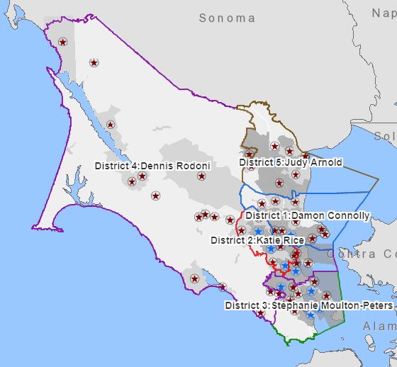
Redistricting determines which neighborhoods are grouped together into a district for purposes of electing a supervisor. For the county government, redistricting means all five supervisorial districts need to have populations that are substantially equal in size. The process is required every 10 years upon release of new census figures to rebalance districts given changes in population. The current map based on the 2010 census is on the Marin County Board of Supervisors’ homepage.
Through the summer and fall, the County will lead an outreach campaign that includes at least four public hearings and information in multiple languages. A new website, RedistrictMarin.org, contains details about the process, including how community members can become involved. By the end of the calendar year, the redistricting effort will result in a new supervisorial district map that shows relatively equal population distribution and compliance with both the Voting Rights Act and state requirements.
The process was explained in detail on June 15 during a Board of Supervisors meeting when the Board and public heard about legal and policy criteria for redistricting and the demographics of the existing districts based on new census estimates. The federal government expects to release final census data in mid-August, and those data must then be adjusted by state agencies. The final state data are expected to be released in October, and counties must base redistricting criteria on those numbers rather than estimates. The Board of Supervisors must adopt a final map by December 15 to ensure the new boundaries are reflected in the June 2022 primary elections.
Staff is planning an informal workshop in mid-August to solicit testimony from the public about the criteria to be used for redistricting, and to demonstrate new online mapping tools. Marin residents will be allowed to submit maps of their own made with an interactive online tool that reflects population changes when a map boundary is moved on the screen. More information about that tool will be released in coming weeks.
The mid-August meeting also will cover the federal and state rules for redistricting, such as definitions of “communities of interest” that should be represented wholly on the revised map. Federal law prohibits racial gerrymandering, and state law requires that the boundaries must be contiguous, easily identifiable, and with minimal division of neighborhoods.
Preliminary review indicates that current supervisorial boundaries are likely to meet all requirements that protect minority voting rights. It is expected that a small population rebalance between some districts will be necessary to reflect population changes. For instance, the population of District 4 (West Marin and pockets of southern and eastern San Rafael) is expected to fall about 7% short of balancing with the population of the other four districts, meaning slight adjustments will be needed to add more residents to District 4 to help balance district populations.
The County of Marin’s redistricting leadership team includes members of the County Administrator’s Office, the County Counsel’s Office, and the Information Services and Technology Office.
Interested in the redistricting process? Sign up to receive periodic e-mailed updates from County staff under the topic “Marin Supervisorial Redistricting 2021” or check the California Secretary of State’s webpage on redistricting. Email the County staff with local questions about redistricting.